
UASA
UAS Aviation Services Australia
UASA FLEET

Albatross 3m wingspan with up to 8 hours endurance for long range missions. Up to 42MP UHD and Hyper-spectral Mapping Imagery. Custom Flight Control and Payload integration assembled in Australia for your data security piece of mind. Data is not transmitted to any third parties as is captured only locally via UASA servers and radio telemetry.
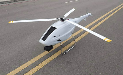
Gaui GX9 Heavy Lift UAV over 4 hours endurance with two extra long range fuel tanks for multiple on-board payloads and magnetometer towing. Custom Flight Control and Payload integration assembled in Australia for your data security piece of mind. Data is not transmitted to any third parties as is captured only locally via UASA servers and radio telemetry.

Nimbus 1.8m wingspan VTOL Mapping Aircraft 1 hour duration with innovative vectoring motors allowing normal fixed wing and multi-copter hovering capability. Up to 24MP HD imaging. Custom Flight Control and Payload integration assembled in Australia for your data security piece of mind. Data is not transmitted to any third parties as is captured only locally via UASA servers and radio telemetry.
Parrot Anafi for 4K/HD Video and 21MP images is used primarily for smaller asset inspection. Parrot Anafi Thermal is also available for use in asset inspections and search and rescue.


DJI Phantom 4 Pro for 4K/HD Video and 20MP images, used primarily for generating 3D models and 2D orthomosaics.
ROV SubC Imaging Underwater Cameras

UASA utilises a small fleet of Unmanned Aerial Vehicles (UAV’s) and Remote Operated Vehicles (ROV’s) that we can rapidly deploy to your site.
We carry several of each type to ensure your mission is never compromised in the event of equipment failure. This also enables us to increase the speed at which we collate your valuable data.
UAV technology is constantly evolving and UASA will maintain equipment that can get the job done now, while always striving to stay ahead of the game.
Our goal is to remain at the cutting edge, though we take a sensible approach to upgrading equipment and related software to proven systems.
We will engage with our clients on a trial basis if required, when introducing new equipment that may better suit their needs.
As the UAV itself is simply a tool to carry the sensor - in most cases, the camera, to where it needs to be, our focus is on the appropriate tool for the task. Higher resolutions or other multispectral requirements usually require larger heavy lift platforms. UASA will evaluate and augment our UAV / ROV Fleet as time goes by as we increase our service offerings.
Currently we have the following Equipment Types:
-
4K/HD Video Cameras with still images to 42MP
-
Micasense Altum Hyperspectral camera
-
LiDAR
- Thermal Cameras
-
Highly sensitive Custom Magnetometer
-
360 degree Cameras
-
Heavy Lift and long endurance Drones
-
Multiple view FPV cameras on large UAVs for complete situational awareness
-
Video monitors and telemetry view from UAVs suitable for on-site client viewing of progress
Drone is the common term for Unmanned Aerial Vehicles (UAV), Remotely Piloted Aircraft Systems (RPAS), Unmanned Underwater Vehicles or Autonomous Underwater Vehicles.